
Tolmie Peak Trail
Hiking From Mowich Lake To Tolmie Peak Lookout
Tolmie Peak Trail is an easy-to-moderate hike starting from Mowich Lake and ending at the Tolmie Peak Lookout tower. The round trip distance is about 6.5 miles and it took us approximately 1.5 hours to reach the top and about an hour to get back. We went in late June and the weather was in the low 70s, dry, and cloudy. The parking lot was full and a long portion of parking on the road was also full. We came across 15–20 other hikers along the route and at the peak there were about 10 other hikers.
Tolmie Peak is named after Dr. William Tolmie, who moved to the Pacific Northwest in 1833 from Scotland. He desired to see nearby Mt. Rainier in closer detail. With a few others, they all set out to explore the area. Tolmie Peak, it is possible that they climbed another nearby peak instead, was chosen to summit in order to get a better view of Rainier. During his journey he also discovered a new plant species named after him — Tolmie’s Saxifrage.
Getting There
The journey begins...
To access the trailhead you’ll need to get yourself to Mowich Lake. The only road that gets you there is Highway 165/Mowich Lake Road and the largest town along the way is Wilkeson. This also happens to be the last stop for gas before you continue the rest of the 22 miles to the lake. So make sure you stop if you need to.
Shortly after you cross over Fairfax Bridge (don’t look down!) you’ll come to a Y — stay to the right. At this point the pavement will turn to gravel and potholes are plentiful. Most of them small, but a few pretty large. This road is suitable for all vehicles as long as you take your time and watch carefully.
The last portion of the road leading to the lake is closed during the winter. Make sure to check road conditions before you leave. However, there is a parking lot (and bathrooms) at this point where you can start your hiking on the Paul Peak Trail and take it to the Wonderland Trail which will lead you to Mowich Lake. Taking this additional route will add about five miles to your hike, so plan accordingly.
There’s a parking lot at the lake with vaulted restrooms. If the lot is full, you’re allowed to park on the side of the road that is near the lake. There’s also a small camp site here which is wide open and near the lot. We’d imagine that most of these campers are those completing the Wonderland Trail.
The Hike
Start by exploring Mowich Lake
First things first: check out the crystal clear water of Mowich Lake. Not only is it clear, it’s also still. Only non-motorized watercraft are allowed on the lake and when we went there was a single kayaker off in the distance. The water was perfect for photos. Due to the waters clarity, you can see a great deal of the bottom.
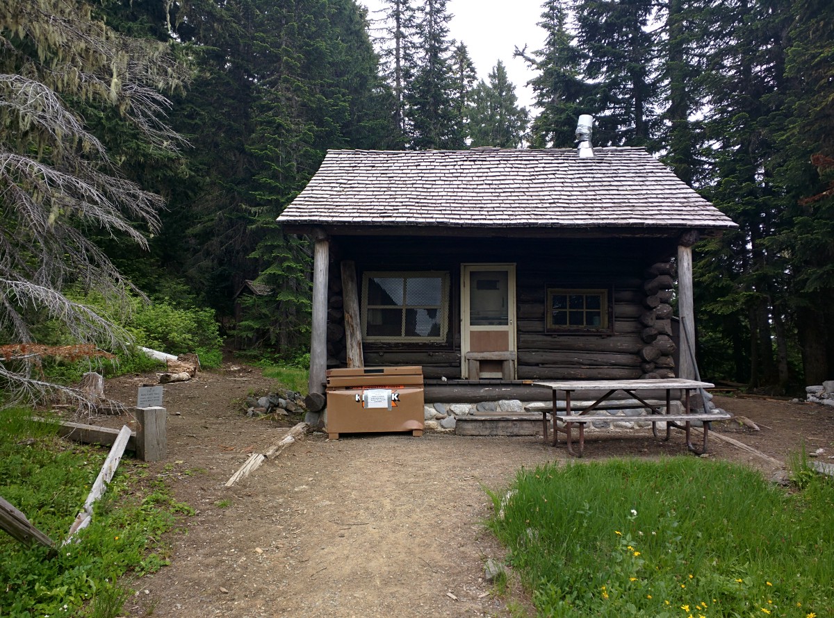
Taking a trail to the north will lead you to a cabin. There were no rangers here but this is another great photo opportunity.


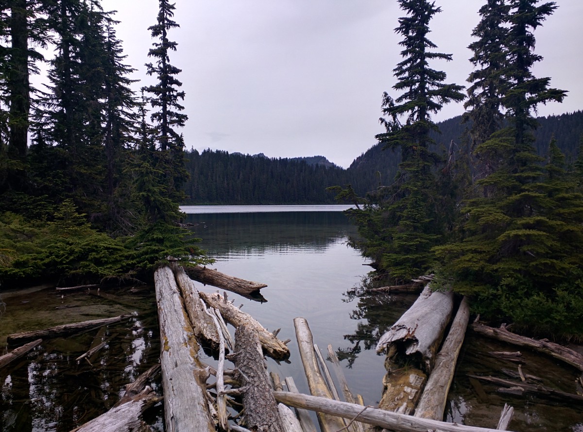
Once you’re ready to move on you’ll want follow the Wonderland Trail along the south side of the lake. Here you’ll begin gradually climbing up and down through tree roots all while the lake is still in view. This portion is about 3/4 of a mile until the trail begins to lead away from the lake.
At this point you’ll start a steeper climb which rises about 360' over a distance of about 1,000'. This was a bit tough, but it’s a great starter for what comes later in the hike.
Now you’ll continue a gradual descent for the next 1/2 mile until you come to the point where the trail splits. You’ll want to go left for Tolmie Peak. If you head right you’ll continue on the Wonderland Trail.
From here the trail continues downhill for just under a 1/2 mile. After that, hopefully you’re prepared for another steep climb — 250' ascent in under a 400' distance. You’ll be sweating here and will probably need to take at least one water break. It’s all worth it though because after this you’ll come across some meadows and then Eunice Lake.

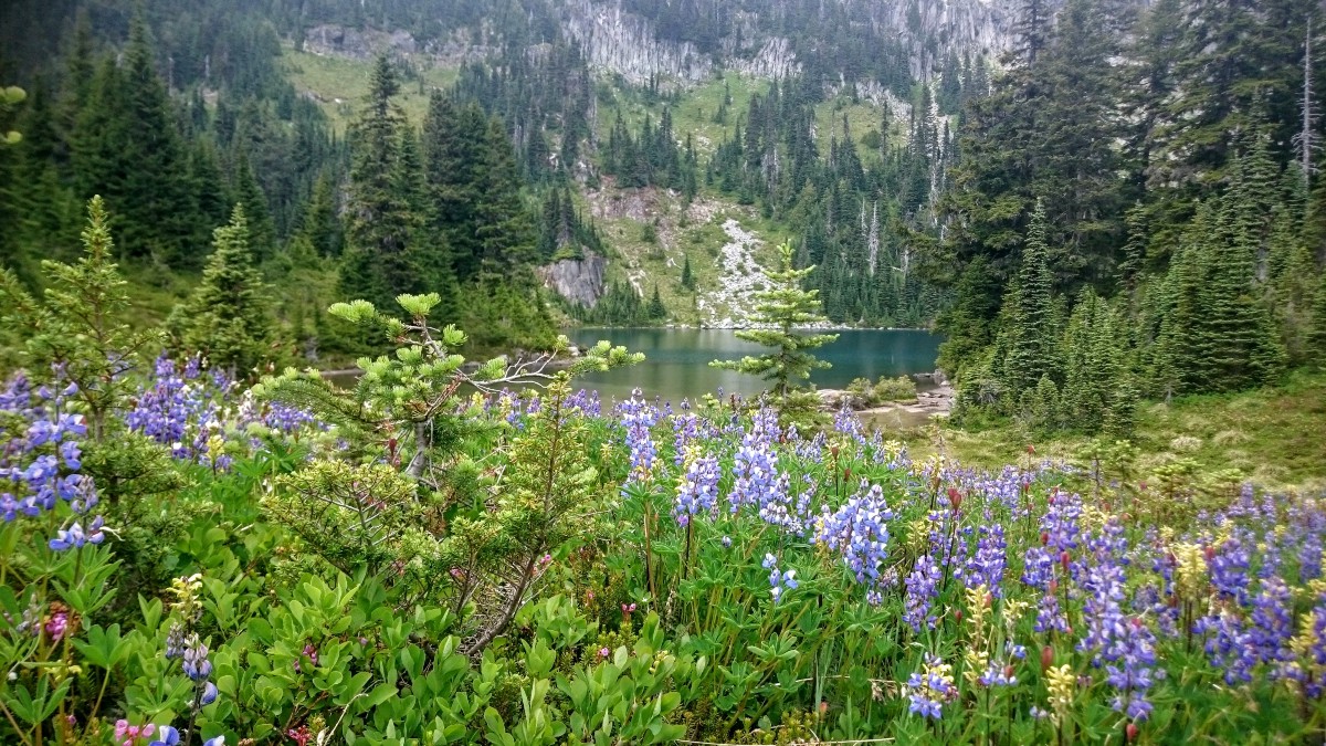


While you’re here at Eunice Lake, take a break and take some photos. We didn’t walk down to the lake but we did see others there. This area was filled with wildflowers. We also saw a deer on the trail right before reaching the lake. One thing to note is that the mosquitoes were pretty bad here. No issues with them before this part or after it.
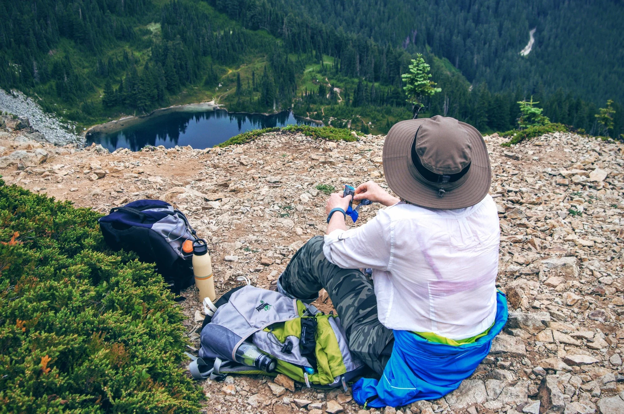
Look straight up the cliff in front of you and you’ll see your final destination — the Tolmie Peak Lookout. Towards the left of the cliff you’ll make out the trail that continues up. There’s a sign nearby indicating that it’s only 0.9 miles to the top. However, your mind is telling you that’s impossible as the route looks much further than that. Don’t listen to your mind. It’s a lot closer than you think.
Once ready, continue onward. The trail climbs about 500' over half a mile’s distance. About half way through this point you’ll see an opening to the left which looks out towards Tacoma. Another great spot for photos. After that you’re almost there!
The Peak
Fire lookout and views
Soon you’ll be able to see the lookout in the distance and it won’t take long to reach. Once there, take a break and take in some beautiful views. It was cloudy during our trip so we could only see the lower half of Rainier but we had a great view of the lake below us and everything else behind us.


From Dr. William Tolmie’s journal after reaching the peak:
“The snow on the summit of the mountain adjoining Rainier on the western side of Poyallip (sic) is continuous with that of the latter, and thus the southwestern aspect of Rainier seemed the most accessible. . . . By ascending the first mountain through a gully in its northern side, you reach the eternal snow of Rainier, and for a long distance afterwards the ascent is very gradual, but then it becomes abrupt from the sugar loaf form assumed by the mountain. Its eastern side is steep on its northern aspect; a few glaciers were seen on the conical portion. . .”


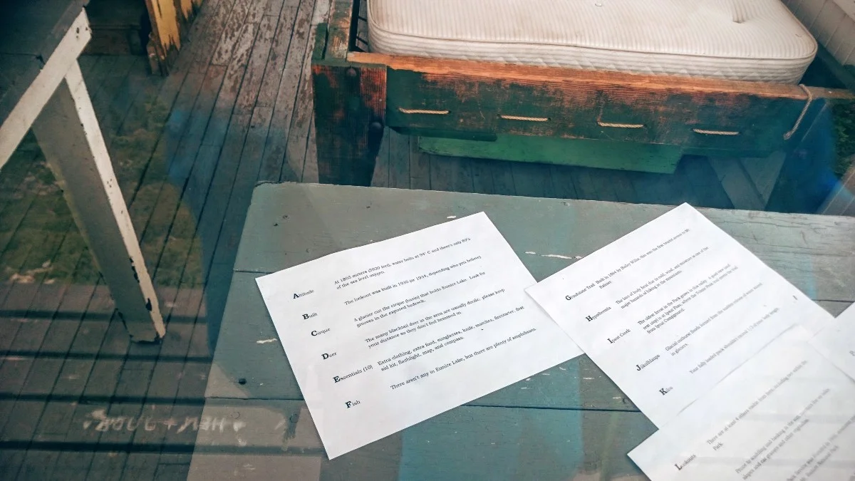
The Lookout cabin was a nice spot to take a break. Though locked, everything inside is visible. Guide books, maps and pamphlets are scattered about. The raggedy mattresses and sparse accommodations lend to the picture of a rugged, not so glamorous existence of Ranger life. We took pictures, took in the views and had a bite to eat while there. After a nice break, we explored a bit more. The trail extends a bit beyond the cabin to another nearby, small peak. The trail is a bit more treacherous, but gave a nice view looking back at the cabin. We maybe spent an hour at the top then packed up and made our way back down. This was a great trail with great views, even on a cloudy day.
Update (07/30/2018): We revisited this hike in 2018. This time with better views. You can read our trail report on the Born In the Mountains blog.


Hey, we appreciate your readership! If you're in the market for new gear and would be willing to make your purchase through our Amazon link, we might get a small commission out of it. No additional cost to you and maybe a little something for us!
Thank you for your support!
Explore More
Other interesting stops along the way
Wilkeson Coke Ovens — Historical site
Fairfax Bridge — Listed on the National Register of Historical Places
Helpful Links
Use these while planing your trip
Washington Trails Association — Tolmie Peak
National Park Service — Tolmie Peak Trail
Mt. Rainier National Park — Fees & Passes
Wikipedia — Tolmie Peak Fire Lookout
Visit Rainier — William Fraser Tolmie
Follow along on our wanderings around the Pacific Northwest.
The only thing better would be being there yourself!
Subscribe to Our Newsletter