
National Park Service Centennial GeoTour
Exploring 100 Geocaches In And Around Mt. Rainier National Park

On August 25, 2016, the U.S. National Park Service (NPS) will turn 100 years old! It has begun holding celebrations throughout the country while building up to its centennial. Here in the state of Washington the NPS has teamed up with Visit Rainier, the official Mt. Rainier tourism organization, to create a centennial GeoTour. It consists of four series, each series having 25 geocaches. This year long GeoTour is a celebration of the park’s birthday which explores a total of 100 geocaches in and around Mt. Rainier National Park.
The first series was released on June 13, 2015. We successfully completed this round on June 24 over a course of two, 2-day weekends and a single day midweek. Each weekend was an adventurous road trip for us. We explored and learned of locations we hadn’t previous known about, we took an enormous amount of photos, we camped each Saturday night in a park, and we also found time to hike some new trails along the way. It was a great opportunity for the two of us to spend some quality time together. Here is Visit Rainier’s description…
The 100 geocaches on the Visit Rainier Centennial GeoTour will highlight the rich history, scenic wonders, quaint communities, and hidden gems of the Mount Rainier region. Can you say “road trip”?!
Yes, yes we can say road trip!
The second series was just released on October 8, 2015. Series three is tentatively scheduled for May 27, 2016, and series four for September 16, 2016. Each previous series will be available throughout the entire year long celebration so there is no rush. Take your time and explore.
Why You Want to Do This
EXPLORE HIDDEN GEMS AND THEIR HISTORY
No matter how familiar you are with the park and the surrounding areas, chances are that there’s some spots along this GeoTour that you aren’t aware of. Each and every geocache introduces and educates you on the significance of its location. If you’re into history you’re going to love this.
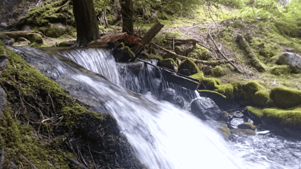
Let’s not forget that we’re visiting Mt. Rainier, the highest mountain in the state of Washington and one of the most dangerous volcanoes in the world! The views and photo opportunities are endless. This is a great chance to get those photos you’ve always wanted. You’ll be spending time viewing this mountain from every perspective there is.
If you’re in it for the bragging rights, you’ll have a chance at earning a special pathtag for each series you complete, as well as a commemorative geocoin upon completing all four series.
What You'll Need
IT DOESN'T TAKE MUCH
Besides fuel and a Mt. Rainier pass there isn’t much else in costs for this. You’ll be away from home for awhile, so time is what you’ll need most. Even if you don’t stay the night anywhere, the drive to the furthest locations and back is going to take multiple hours to complete.
The most important thing you’ll need is a GPS unit in order to input the coordinates of each geocache. No need to worry about spending $100+ on a dedicated handheld unit if you don’t already have one. Your phone will work just fine (even when you have no cell coverage) as long as you download a geocaching app. We used the free app c:geo for Android and it worked great. Bring a car charger for your phone as you’ll certainly need it. Also be sure to familiarize yourself with the app and download all the geocaches to the app before you leave cell service.
You’ll also need a printout of the passport for the series you’re doing. You’ll record the keyword on this passport for each cache you find. Here are the PDF links for Series 1 and Series 2.
Now you just need the coordinates for each geocache location to input into your GPS unit or phone. Geocaching.com is also a partner and they have a whole page dedicated to this GeoTour with all the details you need. Create a free account with them in order to see all the info. They also have geocaching apps available for Android, iOS, and Windows Phone.
Plan Ahead
TAKE THE EASY ROUTE
Like the title says, you’ll be exploring Mt. Rainier and its surrounding areas. That’s a big chunk of land! Some geocaches are located within the park, but the majority of them are outside of it in the small towns and communities that make up the areas surrounding it.
During series 1 we circumnavigated the park twice. Once in each direction. It’s certainly a lot of driving! Take this opportunity to plan ahead to camp at a park or stay the night at a local hotel. We camped inside Mt. Rainier National park one night and another at Yakima State Park.


Geocaching.com and Visit Rainier both provide their own maps of each location. However, these maps only provide an overview of where each geocache is and you can’t interact with them much. We took it a step further and created our own custom Google Maps map for series one and two. This helped in a big way as we were able to plot each location and receive driving directions between points. Feel free to use our map here which you can copy to your own Google account. Once copied, make changes as needed.
Speaking of maps…make sure you take the time to download your Google Maps info before you head out. Cell service is going to be non-existent in a lot of the areas you travel. See this article on how to do that.
Ready, Set, Go...
AND SO THE JOURNEY BEGINS
You should have everything you need to get going. Remember, there’s no rush. Each series has a 3+ month gap between them. There’s plenty of time. Plan your journey however best fits you. Or don’t plan it at all and just get out there to a few nearby geocaches to get the feel for how it all works. You’re going to love it!
As you explore you have three goals: locate the geocache, log the keyword from the inside cover of its container to your passport, and have fun.
Some interesting spots we discovered during series one were Layser Cave, Suntop Lookout, Wilkeson Coke Ovens, and Deep Creek Falls. For series two we’ve completed one geocache so far, Electron, where we found out that “the crookedest railway in the world” is only a few miles from us! Great stuff.


If you’ve been wanting to hike along the Pacific Crest Trail you’ll be happy to know that series one has two geocaches along different portions of this. We read the book Wild: From Lost to Found on the Pacific Crest Trail sometime last year so we were pretty excited to see that this was part of the experience.


Finishing Up
NOW WHAT?
Once you’ve located all 25 geocaches in a series you can mail your completed passport to Visit Rainier and a few weeks later they’ll send you a series specific pathtag. This is a nice token to attach to a key ring, backpack, or pretty much anything else you can think of.
After completing all four series we’re told that we’ll receive a commemorative geocoin. We’re looking forward to that!
If you had a great time with this then we encourage you to continue your geocaching journeys with Geocaching.com. They do so much more than the Mt. Rainier GeoTour. You can find other GeoTours as well as random geocaches located in and around your community and the places you visit.
Wander More, Worry Less!
Discovered Things
Our photos


Hey, we appreciate your readership! If you're in the market for new gear and would be willing to make your purchase through our Amazon link, we might get a small commission out of it. No additional cost to you and maybe a little something for us!
Thank you for your support!
Follow along on our wanderings around the Pacific Northwest.
The only thing better would be being there yourself!
Subscribe to Our Newsletter