
Hiking Silver Star Mountain
Mountain Views, A Summit, Wildflowers, and Forest
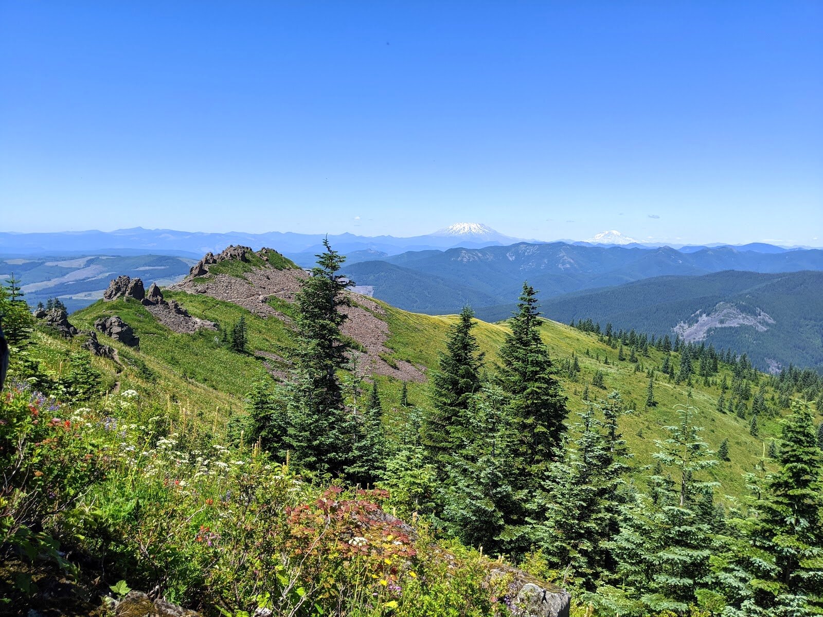
A view of Mt. Hood in the distance from the top of Silver Star Mountain.
The opportunity to enjoy wildflowers, views of 5 significant mountains, a natural rock arch, and two different trails drew us to this hike. Those are some of the things you’ll see while hiking Silver Star Mountain. This easy-moderate hike should be on everyone’s must-do list! The drive up may be challenging, but the hike itself is rewarding.
“In a meadow full of flowers, you can not walk through and breath those smells and see all those colors and remain angry. We have to support the beauty, the poetry, of life.”
A Rough Forest Road Drive
Unfortunately, we didn’t take any photos of the rough parts of the road. This is at the top.
If you’ve ever looked up any trip reports for this hike, the main takeaway mentions how the last ~2 miles of Forest Road 4109 is very rough. Like every report mentions, and we can verify, a high clearance vehicle is a must. The total forest road drive is 7.2 miles and begins with Forest Road 41. Those first 5 miles should be ok for most vehicles. We did see some people decide to park in an open area and walk the last 2 miles in. We even thought about doing that ourselves at first. Then we decided to put the Cherokee in 4LO and give it a try. One of us got out to check clearance and guide while the other drove. (By the way, if it’s helpful for you to compare your vehicle, our Cherokee has 8.2” of clearance.) Of these last 2 miles, there were only two or three significant ruts to get up and over. We eventually made it to the parking area and noticed it was all trucks up here except for two SUVs. The lot was full, so we had to park along the side of the road.
You can check road status for Forest Road 41 and Forest Road 4109 before heading out. You’ll also want to make sure you saved an offline portion of this area in Google Maps since there is no cell service.
The Hike
A lot of wildflowers on the beginning of Ed’s Trail.
Once we were parked, we applied sunscreen and bug spray, put on our backpacks, and proceeded to the trail. There were plenty of people coming and going on this perfect day. The first thing we noticed was the abundance of wildflowers. The day was sunny with a light breeze carrying the sweet scent of nectar. Butterflies and moths touched-down ever so briefly on one blossom then the next. The buzzing of bees was nature’s melody as these industrious toilers vibrated on each flower with such urgency to collect as much pollen as possible. Hummingbirds flew swiftly and gracefully among the blossom, catching our eyes each time they were near. Between the floral buffet and the pollinators, we found ourselves making frequent stops to take photos. The other grand thing from the start was the view of Mt. Saint Helens, behind us. This mountain would stay in our rear-view the majority of the hike.


As we climbed upward along this wide, rocky double-track section of trail, we passed many other hikers. Some of them were wearing masks, but the majority were not. We had ours on the ready the whole hike and used them while coming into close contact with others.


Gaining in elevation, behind us, we began to notice the top of Mt. Rainier appearing just above the mountains in the foreground. After about 30 minutes or so, Mt. Hood became visible just in front of us. Facing Mt. Hood, we had a great view of Star Creek Canyon below and rocky cliffs to the right. This is also the beginning of Ed’s Trail. However, we somehow missed the trailhead marker and proceeded to follow everyone else up the current path.


A little further, we came to an intersection, off to the right was a spur trail leading to a viewpoint facing west/southwest. It was a bit hazy in the distance, but we were able to make out the Columbia River and Vancouver area. Some trip reports did say they were able to see as far as the Pacific, no luck for us. After snapping a few photos, we returned to the main trail.


At this point, we had the option of continuing up the rocky portion or veer left and head up a grassy road-like path. Remembering Silver Star Trail follows the west side of the ridge and Ed’s Trail follows the east side, we headed toward the east to jump onto Ed’s Trail. There were no trail markers at this point. As we continued on, views of Mt. Saint Helens, Mt. Rainier, Mt. Adams, and Mt. Hood all became more spectacular. With every step we climbed higher, we could see a little bit more of each mountain. We were surrounded by a hilly alpine meadow of wildflowers. The trees here were sparse, with none being anywhere near us to provide shade.


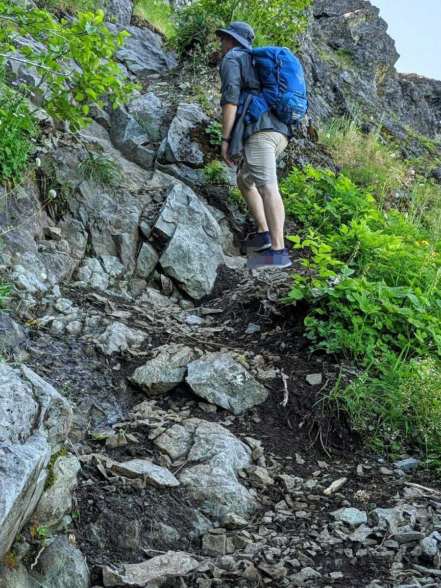
We began to make our way nearer to the ridge’s rocky cliffs. Here, the trail consisted of large, fallen rocks we had to walk over. Off to the right was a memorial marker to Ed. This time of day, and being on the east side of the ridge, we were granted moments of shade.


We took our time and made our way to the rock arch gateway and stopped for photos. After we were through the arch, there was a wide, shallow sort of cave in the rock wall to our right with room to sit. A little further along the trail there were a couple of places we had to climb up the rock-face, but nothing too technical. There were plenty of safe places to plant your feet and ample handholds. The trail continued up and around this rocky ledge then descended a bit into the forest.


Entering beneath the tree canopy was a sweet relief from the sunshine. The trail was compacted earth lined with bear grass and was already winding back upward. We came to an intersection with signage that pointed the way to the summit and directed to several other trails. There were more people on this portion of the trail. The trees thinned, and we came to another intersection, there was no sign, but a pyramid-shaped pile of rocks indicated this was the trail to the summit on our left.


We made our way to the top, which stretched to our left and right. There were small groups of people taking in the views and what appeared to be a wedding party and photographer. We found an unoccupied spot apart from the others to the left. There were plenty of flat rock surfaces to sit on. We took off our packs and enjoyed the breeze as we cooled off and took in the panoramic views. We took photos, rested, and enjoyed a bite to eat in the surrounding beauty. We spent probably 30-40 minutes at the top before donning our packs and beginning the return trip.


We took Silver Star Trail back, passing our original path to the right. This kept us under the forest shade for the first stretch. Soon enough, we were back out in the meadows among the wildflowers. The trail was again rocky and dry stretching out before us. There were several rocky outcroppings jutting upward among the flowers, giving contrast and visual interest to our surroundings. The trail seemed to go on longer than the path up, but that’s just how it feels sometimes. We finally made it back to our vehicle, took off our packs, changed shoes, and began the drive back. We did a quick stop at nearby Sunset Falls, before hitting the highway.


Final Thoughts
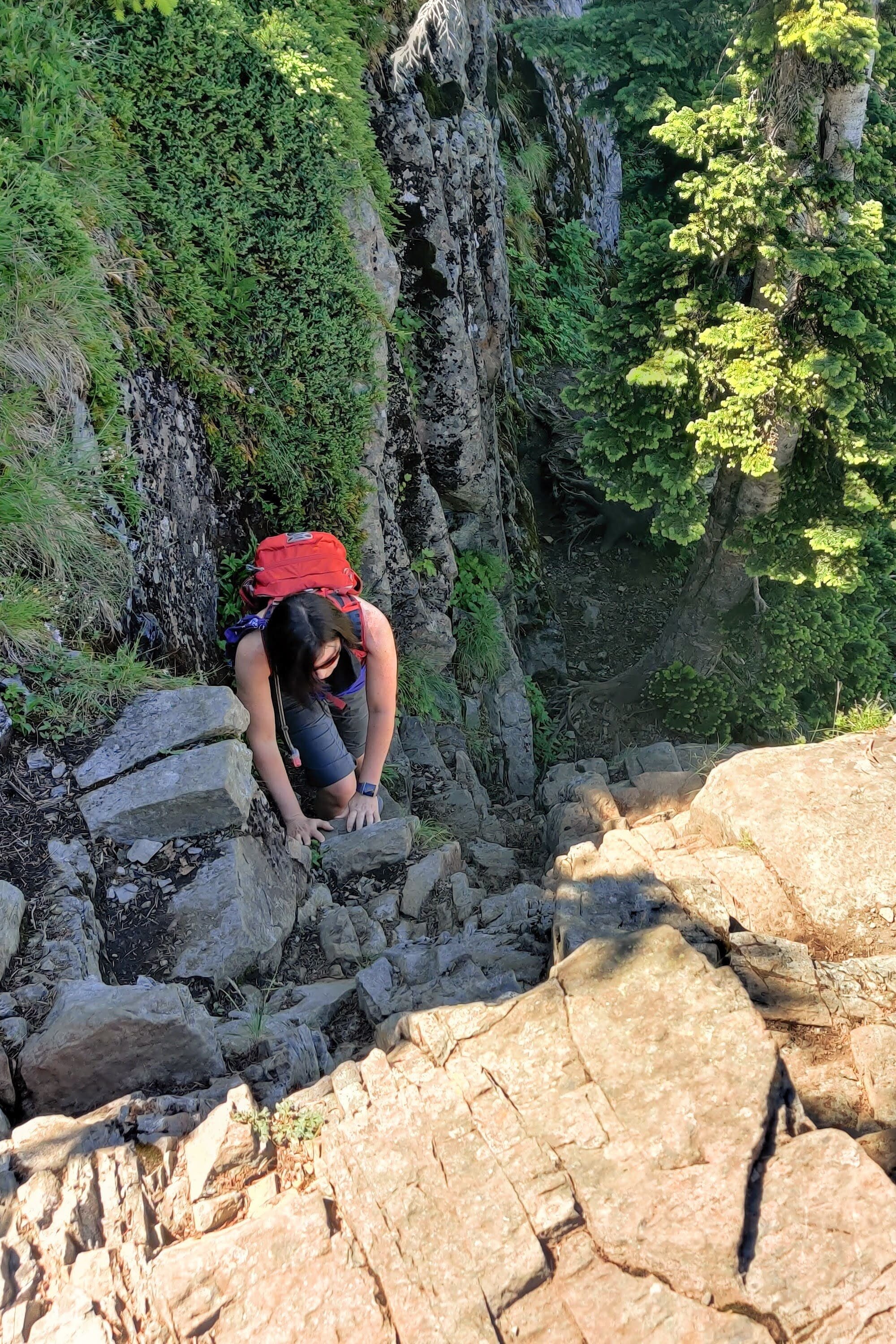
Taking precautions while hiking on Ed’s Trail. Natural rock arch in the background.
The variety of wildflowers we got to appreciate here was second to none. Meadows like this on a bluebird day gave this hike a sort of fairytale quality. Mountains, forests, meadows full of flowers, pollinators galore, and gorgeous views made this an A+ trip for us. If you go, take Ed’s trail on the way up, there are views along that way and the rock archway that you would not otherwise experience. As always, take your time, enjoy each moment, each scene.
Let us know in the comments section below if you’ve already hiked Silver Star Mountain or if you plan on hiking it.
Hey, we appreciate your readership! If you're in the market for new gear and would be willing to make your purchase through our Amazon link, we might get a small commission out of it. No additional cost to you and maybe a little something for us!
Thank you for your support!
Helpful Information & Links
Coordinates: 45°46'21.0"N 122°14'40.1"W
Distance: ~5.3 Miles Roundtrip
Difficulty: Easy-Moderate
Elevation Gain: 1,414’
Pass Required: None
Wildflowers Seen: Indian paintbrush, lupine, Kelley’s lily, alpine rose, prairie thermopsis, alpine sweetvetch, smooth oxeye, Cascade penstemon, goatsbeard, alpine aster, Pacific bleeding heart, subalpine spirea, thimbleberry blossoms, western wallflower, red columbine, mariposa lily, larkspur, wild iris, explorer’s gentian.
Follow along on our wanderings around the Pacific Northwest.
The only thing better would be being there yourself!