
Hiking Baldy Mountain
Camping at Big Pines Campground In Yakima River Canyon
Sunset
With 360-degree views at the top and a good overlook around the midway point, the TP Jim Trail on Baldy Mountain can be a little challenging but well worth it. It's only 2-miles to the top, but the nearly 2,000' elevation gain slowed us down quite a bit. However, all that effort does come with rewards from this vantage point: the Yakima River and campground at the bottom, Mt. Rainier, Mt. Adams, and Mt. Hood visible in the distance, as well as the sparse, hilly eastern Washington landscape to be seen all around.
“To climb steep hills requires a slow pace at first.”
Big Pines Campground
Big Pines Campsite
Big Pines campground is the largest of four Bureau of Land Management (BLM) recreation sites found in Yakima River Canyon. It is located roughly midway between Ellensburg and Yakima, along State Route 821 in Kittitas County. This windy, scenic byway follows the Yakima river through desert hills, basalt cliffs, and some historic marker stops.


We arrived at camp around 7 PM after about a 2.5-hour drive. Locating our site was quick and straightforward. Upon stepping out of the Jeep, the first thing that made itself known was the wind. Our guess would be around 20-30 MPH constant wind with frequent stronger gusts. Unpacking and setting up the tent was a bit challenging. Luckily we purchased some heavy-duty stakes a few years back, and they were needed since the ground was full of rock. Even with the better stakes, the wind was so strong that we placed larger stones on the tent's inside and outside corners.
Our next challenge was getting the fire started. Even though the fire pit had a raised metal barrier, the wind quickly blew out the flames while trying to get it going. We gathered loose sticks and larger rocks to build up a wall. That still didn't help. We eventually used the lid to the cooler to block the wind. After a few additional attempts, we finally got it going.


With that out of the way, we pulled up our chairs and relaxed with a few drinks, taking in the nearby scenery. Directly across the highway was the mountain we'd be climbing in the morning. Behind our campsite was the river with a few other campers dipping their toes. About an hour later, the sun began to set, and the clouds gave way to provide us with beautiful sunset hues.
We stayed up for another hour or so before we called it a night and climbed into the tent.
A Morning Hike Up Baldy Mountain
Hiking Baldy Mountain
After waking early, we had a quick bite to eat, gathered our gear, and put on packs. We crossed the highway and walked along it a short way until we located the trailhead. At least, we thought we found the trailhead. There were wooden posts in the ground with a metal gate on one side and some barbed wire wrapped around it all. One of the posts also had a BLM sticker on it. So we proceeded onward.


This single track, dirt trail, made its way through the wild sagebrush with flowers here and there. The first ¼ mile was pretty easy hiking. After that, though, the trail gradually became steeper and steeper with more and more rock. We stopped a few times to take photos and to catch our breath. The steepness continued for another ⅔ mile or so before finally reaching a leveled, rocky outcropping. It took us roughly 50 minutes to reach this point.


Here we had great views of the campground below, the winding river, and the hills on the other side of the river. Up to this point, the wind had started to pick up gradually. Looking east, we were able to make out the radio tower at the top of the mountain. And from our current location, it didn't look too far away or more difficult to reach.


We trekked on. The next ¼-½ mile was relatively level and easy to navigate. The trail passed by and thankfully, not through several scree fields. Beyond that, the remaining hike was nearly as steep as the first portion. Along the way, we passed through another gate-like area made up of rock-filled fence posts with attached barbed wire fencing running in either direction. There was no actual gate here, just an opening welcoming us to even steeper terrain.


The majority of the trail edges up right along this messy tangle of a barbed-wire fence, getting pretty close at times. You'll want to make sure your kids or dog don't get tangled up in this. As we took many breaks through this section, we would turn around to be greeted with views of Mt. Rainier and Mt. Adams. After climbing a little more, Mt. Hood became visible.
After many more water breaks, we eventually reached the top. The first thing that greeted us was a makeshift flag made out of PVC pipe and a strip of yellow caution tape flying from its top. This hilltop marker looked like an excellent spot for a photo. Walking a little further, we noticed a memorial plaque, and then we reached the radio tower.


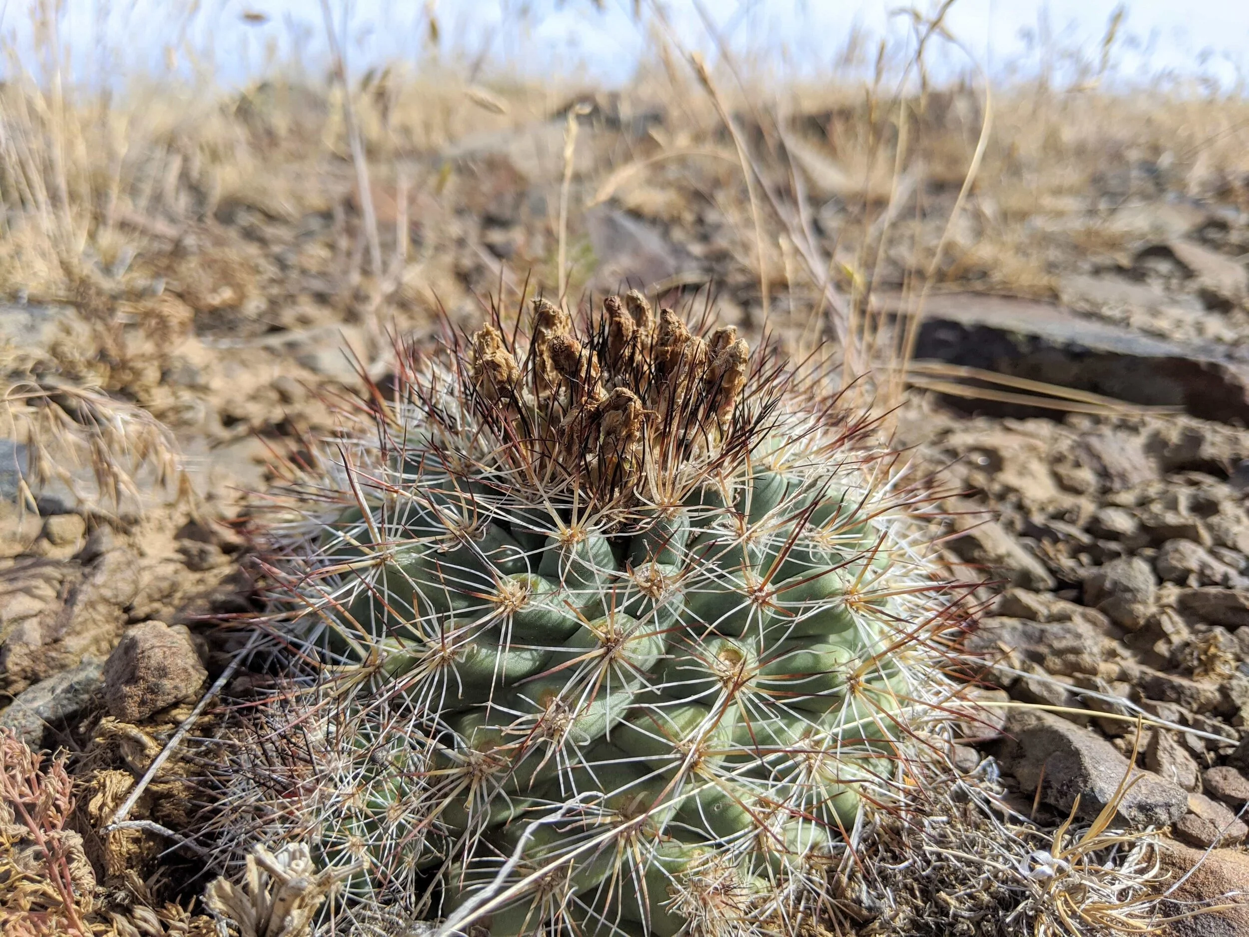
The wind was high; the views were excellent. Yellowed grasses, flowers, and small clumps of cactus with bees buzzing and moths playfully circling from one tiny shrub to the next covered this area. We kept hearing what we initially thought was someone yelling. We scanned the area, hoping no one was in trouble, only to realize the wind was carrying the cries of cows from the pasture from far below. Our binoculars came in handy from this precipice. We tried locating Mel's Hole from this vantage, but no luck :). Let us know if you find it! We took about 10 minutes to look out at the fantastic eastern Washington landscape before heading back down.

The trek down was more difficult than up, due to the steep trail. We didn't have them, but we would recommend trekking poles for this hike. After a while, it became very hard on our knees. We stopped a couple of times and started thinking about that even steeper portion at the beginning, wondering how we'd get down that. Sure we'd be on all fours sliding down it. Regardless, we had to get back to camp, so we kept moving.

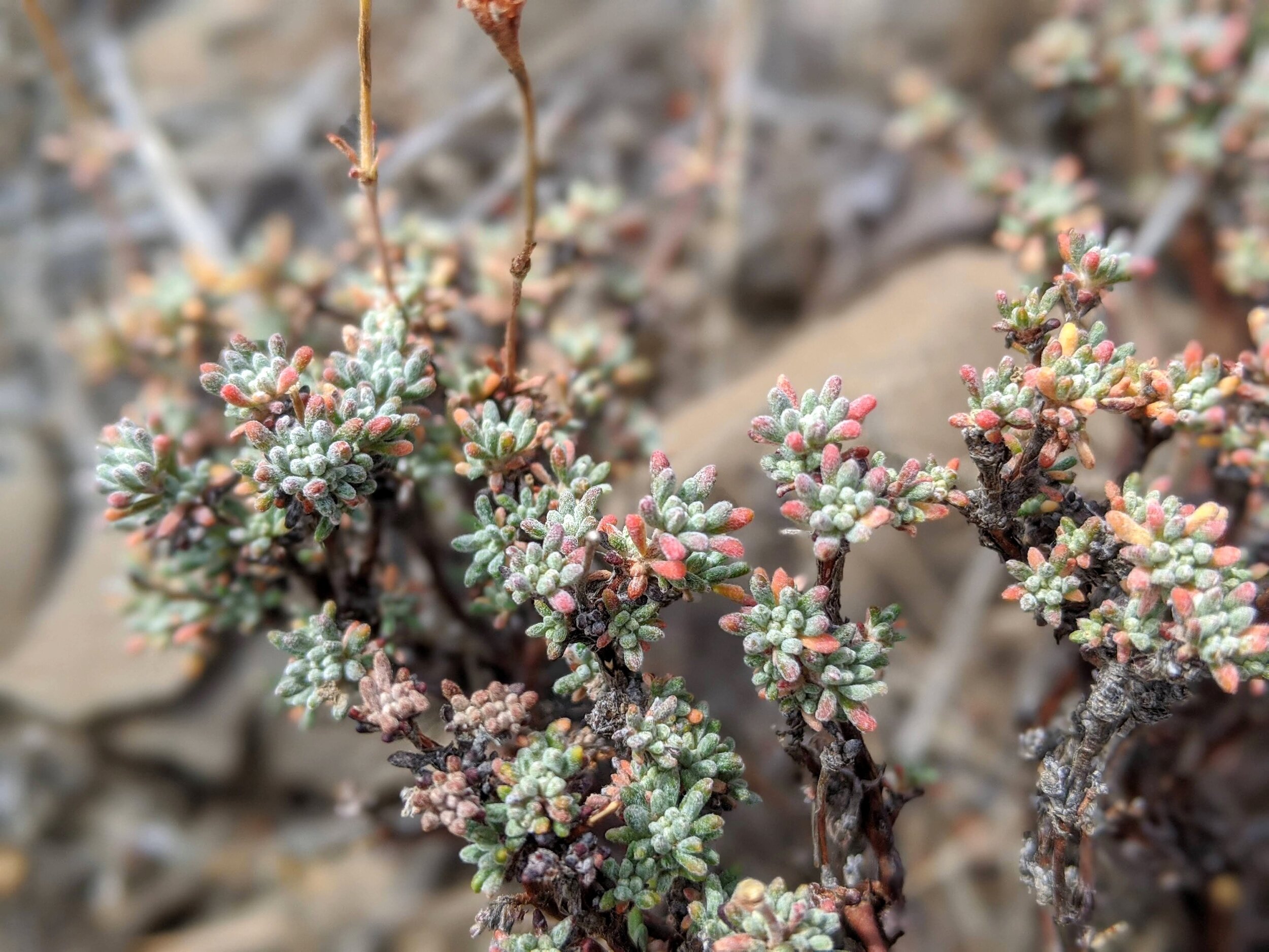
We started noticing more of those miniature cacti during our descent, wondering how we missed them heading up. We eventually reached the leveled out portion, and that's when we noticed other people on the trail for the first time. They must have only come as far as the outcropping because they were just starting their return trip. We can't blame them, heading up that first part was severe enough.
As we continued onward, we noticed that something didn't look right. The trail seemed to go too far right. However, that's where the other people were, so we continued for a bit. After a while, we figured we were on an alternate trail leading up/down to the outcropping. This longer route was good news, as this way wasn't anywhere as steep as the one we took up.
We continued on this route. It added a little more distance as it gradually wrapped its way around the lower portion of the hill. Still, we didn't have a problem with it, so long as we didn't have to scramble down the part we initially used. This was much better on our knees.


And just like that, we made our way to the original gate where we started. This alternate route, or even the official route, as one person told us, was somewhat obscured when we first set out. If you're looking for the easier way, continue past the gate with the BLM marker. See our map below to understand better.
Leaving Camp Early
You can’t really see it, but the wind was super strong.
After returning to camp, we attempted to relax. However, with no trees to provide shade and the ever-increasing high winds, relaxation wasn't possible. We attempted to put up our canopy for shade, but due to the rocky ground, we were unable to stake it down. We disassembled it and took a short walk around the area. We returned to the site and decided to leave early instead of staying the additional night. So we packed up and headed home.
Final Thoughts
Although the camping wasn't as enjoyable as we'd hoped, the hike, on the other hand, was a good one. Knowing this eastern side of Washington is high desert, we didn't really expect much in terms of trees. We have experienced the winds on this side before, but this time around, they just seemed stronger. Since the campsite is mostly sand/dirt, the winds blew this straight up the sides of our tent and through the mesh portions for a constant sand shower. Being a BLM site, the provided toilets are vaulted without any running water. This is all perfectly tolerable, really, just set your expectations, or do like most of the other campers and come in an RV. There were plenty of folks rafting and kayaking and buses brought people in for rafting tours. So, if you like water recreation, that's a bonus.
The hike was undoubtedly the highlight of this trip. The elevation change over the shorter distance made for a challenging journey, but the promise of ever-widening views pulled us forward. The temperatures were mid to high 70's, but the strong winds kept us cool.
Panoramic view from the mid-way point.
A windy hike to Baldy Mountain. This is the view from about halfway.
Hey, we appreciate your readership! If you're in the market for new gear and would be willing to make your purchase through our Amazon link, we might get a small commission out of it. No additional cost to you and maybe a little something for us!
Thank you for your support!
Helpful Information & Links
Coordinates: 46.795285, -120.458288
Distance: ~4 Miles Roundtrip
Difficulty: Moderate-Difficult
Elevation Gain: 1,982’
Pass Required: Yes. America the Beautiful (Interagency Pass) or $5/day-use
Follow along on our wanderings around the Pacific Northwest.
The only thing better would be being there yourself!
Subscribe to Our Newsletter