
Heybrook Lookout Trail
Mt. Baker-Snoqualmie National Forest, Washington

On the western edge of the Central Cascade mountain range is Heybrook Lookout Trail #1070. It traverses through a second-growth forest that leads to a seven flight observation deck overlooking many nearby peaks, a close town, and more. The 900-foot elevation gain, just over a mile in length, had us catching our breath more than a few times on the way up. The views from the top on a sunny and clear day made the hike well worth it.
“Each moment of the year has its own beauty.”
The Hike
The day was sunny and clear, not a cloud in the sky. Perfect for photos! The low 40 degree temperatures made wearing a light jacket good enough as long as we didn’t stop for too long.
We started out at the trailhead sign, which was oddly covered in thick plastic wrap, at 2:43 P.M. Next to it was a “Register Here” sign with a drop box. We opened the lid, no blank slips of paper or a pencil, closed the lid and moved on.
The trail starts out heading east, parallel to the highway, for a short distance. We crossed over a wooden bridge covered in snow. Quickly enough, the trail began to bend to the left and we started our climb up.


As we headed up, the noise of traffic on the busy highway gradually faded and the sounds of nature took its place. The first half of the trail was mostly dry with few muddy areas.


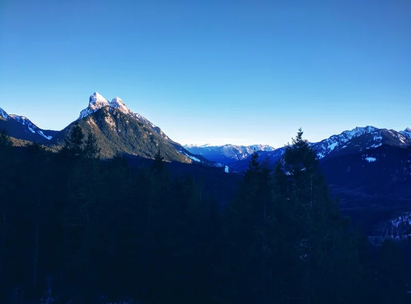
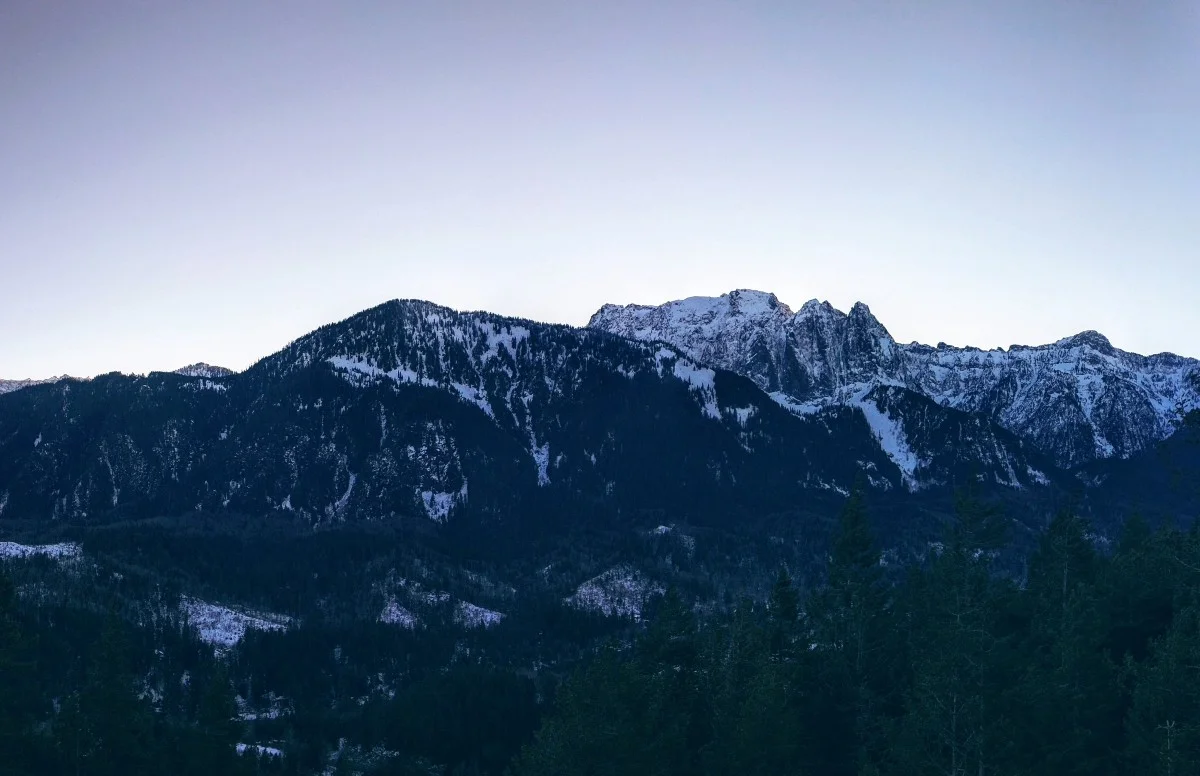
Views of nearby mountain ranges and peaks were out of sight nearly the whole time until we reached the top.


Other trip reporters from WTA mentioned they wore micro-spikes over their boots due to the slippery packed snow. We have yet to level up to a pair of these but still decided to make the hike. Our nerves were eased as soon as we saw two hikers running past us downhill, each wearing a pair of canvas Vans on their feet. Shortly behind them was the rest of their party, a group of 7+ others, all wearing Vans as well. We knew then that we’d be just fine without the spikes.
Along the trail there were numerous downed trees. The further up we went, the more trees were down. Most of them were all easy to navigate over or under.


Once we approached a wooden staircase the trail became permanently covered in snow from here to the top. We took our time. The snow was packed well from all those hiking before us. It was slippery, but manageable.
We took a few water breaks along the way, letting a couple with their dog pass us at one point. Considering how late a start we had, we were surprised at the number of people out here. Plenty more were coming down as we were heading up. Our pace was a bit slower than normal as we were being diligent to have firm footholds with each step.
Nearing the end of the trail we came to a clearing with a pretty good view of the mountains to the south of us. We stopped for a photo and water break. Ready to proceed, we turned around and there was the lookout, towering over us just a bit further up.


This last portion of the trail was the hardest due to the amount of snow, large rocks, and steepness. Probably only 100 or so feet from here, but it did take some patience to get through it.
It was 3:29 P.M. as we reached the top and the first thing we noticed was the wind. Strong and cold. The hiking itself to this point kept us warm, but taking a break to catch our breath and drink some water here quickly changed that.
There were maybe 6 other hikers and 2 dogs already here. Besides the lookout there was also a picnic table and a sign pointing towards a toilet (not certain if there actually was a toilet). Wandering anywhere outside of a 25-foot radius of the lookout left us in knee-deep snow.
When we were rested, we started the climb up the structure. The current tower on site was built in 1965 by Everett Mountaineer volunteers. The original 1925 tower was designed by former governor of Washington State, Dan Evans.


Once at the observation deck we had great views towards the south and east. Everything within sight here being Mt. Baker-Snoqualmie National Forest land. The more prominent peaks were Mt. Index, Mt. Persis, Merchant Peaks, and Baring Mountain.


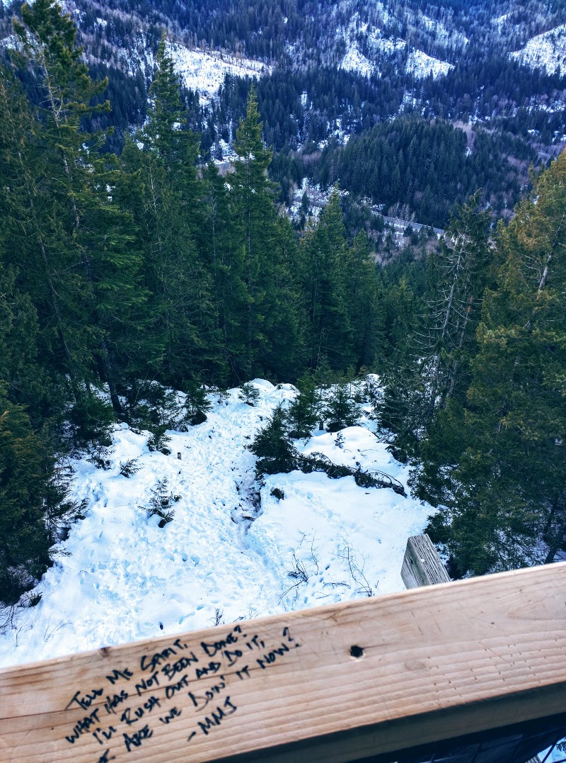

We stayed for about 10 minutes before the wind was too much to bare. There was plenty of writing all over the deck from previous hikers. The author of the longest message was kind enough to leave a tl;dr version :-)
We headed back down the stairs, had a quick snack, took a few more photos, then began our descent at 3:50 P.M.


Thinking that the slippery packed snow was going to make things more difficult heading down than up, we were surprised at how easy it was to just foot-sled our way down. Probably not the best thing to do for the trail, but hey, it was too much fun to pass up!
We passed four others that were heading up. Stopping to ride a bouncy tree for a bit, hanging from another, and only having one slip and fall on the bum, we returned to the trailhead at 4:30 P.M.


Time spent: 46 minutes up, 21 minutes at the top, 40 minutes down. 1 hour 47 minutes total.
Getting There
Parking for the trail is located along the edge of busy U.S. Route 2, two miles east of the town of Index. A little over an hour’s drive from Seattle. All the cars at the time of our visit were parked in a single file line on the north side of the highway.
There are no restrooms available at the parking lot. If needed, stop at one of the many stores before or at Index. We headed further east of the parking area for about 7 miles trying to find somewhere to stop and found no options before turning around.
There were no signs at the trailhead indicating that a pass was required, nor was there any pass information on the Forest Service website.
Overall Thoughts
This is a well trodden trail. Many of the people we encountered were teenagers and had little use for trail etiquette. Rather than being upset by descending passersby not yielding, we used these opportunities to step aside and catch our breath. Slippery or not, this was a fun hike. The surroundings were lovely and the views at the top on this clear day were just amazing. We’re happy we made the trip!
Hey, we appreciate your readership! If you're in the market for new gear and would be willing to make your purchase through our Amazon link, we might get a small commission out of it. No additional cost to you and maybe a little something for us!
Thank you for your support!
Wander More, Worry Less!
More Photos


Follow along on our wanderings around the Pacific Northwest.
The only thing better would be being there yourself!
Subscribe to Our Newsletter